
I haven't exhaustively looked at all cases, but it appears that, at least for the "bad data" case 05:10-06:10 AM on 5 June at Platteville, dew formation caused the bad h2o and presumably co2 values. During this case, RH is at least 97% and w'h2o' fluxes during the preceeding hour are negative (water deposition to the surface).
I note that this occurred despite the Li7500 being mounted at 45 degrees upside down, but presumably dew on the mirror also would affect the signal.
(This analysis was assisted by David Reed.)
RH.6m at Marshall (TRH010) looks wrong from Jun 9 06:10 to 07:30 MDT. 

All the mobile ISS data were copied with rsync from the site back to the FTP data directory as of 2009-06-08 04:00 UTC.
iss1:/> cd /iss/ds
iss1:/iss/ds> rsync -av ./ iss@shiraz.eol.ucar.edu:/net/ftp/pub/archive/iss/asp/iss1
This includes all the GAUS data, raw SPC, raw NIDAS, and NIMA SPC and netcdf.
8June09 ~10:00MDT
Platteville turned off, station returned to Boulder.
Since Jun 7 19:05 13:05 MDT Marshall adam was only recording the 2 inputs on the viper serial ports, not the emerald serial card. This is the PC104 interrupt issue that I thought I had fixed....
As a result we only have data from the 2m sonic (and GPS) from that time until the system was remotely soft-rebooted on Jun 8 09:04 MDT. It stayed up for 10 minutes and then hung. It was hard-booted at 10:00.
7June09 ~16:15MDT
Swapped Pocketec.
The area had some rain this afternoon and the Echo is reading ~34 now. Everything else seemed reasonable.
Data was uploaded in Boulder via porter.....
porter:/h/eol/militzer-> copy_pv_usbdisk.sh
usbdisk disk not mounted. Trying to mount /media/usbdisk...
source directory=/media/usbdisk/projects/ASP09
destination directory=/scr/isfs/projects
Filesystem 1K-blocks Used Available Use% Mounted on
/dev/sdd1 57685532 407292 54347988 1% /media/usbdisk
Filesystem 1K-blocks Used Available Use% Mounted on
eve.eol.ucar.edu:/Volumes/ISFS
1953415136 1534104160 419310976 79% /scr/isfs
/h/eol/militzer
sending incremental file list
ASP09/
rsync: failed to set times on "/scr/isfs/projects/ASP09": Permission denied (13)
ASP09/raw_data/
rsync: failed to set times on "/scr/isfs/projects/ASP09/raw_data": Permission denied (13)
ASP09/raw_data/platteville_20090606_221745.dat
16141416 100% 11.74MB/s 0:00:01 (xfer#1, to-check=2/5)
ASP09/raw_data/platteville_20090607_000000.dat
113755580 100% 10.60MB/s 0:00:10 (xfer#2, to-check=1/5)
ASP09/raw_data/platteville_20090607_120000.dat
98214290 100% 10.23MB/s 0:00:09 (xfer#3, to-check=0/5)
sent 228139407 bytes received 77 bytes 10139532.62 bytes/sec
total size is 228111286 speedup is 1.00
rsync error: some files/attrs were not transferred (see previous errors) (code 23) at main.c(1040) [sender=3.0.5]
Daily Report for Sat 6 June 2009
MISS at Marshall for ASP mini-field project
Fine, mainly sunny with light winds. Around mid-day on some mid-level clouds and widelyscattered low level CU. Also some high level cirrus. Less haze than yesterday. Brief brisk westerly breeze around 2330Z.
Four soundings 15Z, 18Z, 21Z and 0Z :
15Z was relaunched as first sonde string separated from RS92 unit.
21Z 7C temperature bias (high) on pre-launch checks. String didn't fully unwind so winds may be a little noisy.
0Z Lost GPS at launch. It was tracked visually to about 350mb flying in an almost striaght line at approx 60 deg azi and 60 deg elevation.
18Z and 21Z showed some evidense of gravity wave breaking in winds at upper levels.
Wind profiler mainly only seeing boundary layer scatter. Ceilometer seeing clouds around 4 - 5 km most of afternoon.
For two periods of an hour or more today, Rpile.in.mfs went to zero.
After trying to reseat connectors/wires in the logger box, the fix was simply to cut and restrip the wires inside the logger for the 2L/2H inputs.
6June09 ~16:15MDT
Swapped Pocketecs. Gordon merged.
Echo probe was reading ~ -67, tried the other probe more recently installed in the ground by CG, and it also was reading about the same. Left the original one connected to logger. Probably will be small spike in data from short swap.
Other data appeared reasonable from quick look.
State variables
---------------
P: ok
T: ok
RH: ok
Radiation
---------
Rnet: ok
Rsw: ok
Rlw: ok, but spike in Rlw.in between 0930 and 1000 on June 6
Rsum: see Rlw
Soil
Tsoil: ok
Qsoil: ok, but spike at 1520, June 5; swapped sensors?
Gsoil: ok
Csoil: see Qsoil
Prop Vane (pv)
---------
Spd: ok
Dir: ok
Sonics
------
spd: ok
dir: ok
w: ok
u'u': ok
v'v': ok
w'w': ok
u*: ok
tc: ok
tc'tc': ok
w'tc': ok
Licors
------
h2o: negative spike at pv 0600, June 5
h2o'h2o': positive spike at pv 0600, June 5
w'h2o': ok
co2: negative spike at pv 0600, June 5
opposite?? excursions at 4m and 10m at mfs; ~1800-1900, June 5
co2'co2': ok
w'co2': ok
Daily Report from MISS at Marshall in support of ASP mini-project
Fri June 5, 2009
Wave clouds over Bouler this morning, with increasing mid-level clouds during the day. Light southerly and easterly winds. Quite hazy. Late afternoon a thunderstorm with lots of lightning and oaccaionally heavy rain passed over.
Four soundings were launched : 1500 1730, 2030, 2330 UTC. All soundings went well with ASP students in attendance. Boundary layer appeared to be low (400 - 600m) in all cases. 1730 and 2030 showed evidence of gravity wave breaking at upper levels (above 100 mb). 2330 sonde was launched as the thunder storm approched and appeared to travel along with the storm to the NE.
Wind profiler worked well although not seeing much above the low boundary layer. During the early part of the storm there were cases of unusally clear separation of precip and clear-air signals in the Doppler spectra.
Surface station showed westerlies last night, not seen in the profiler so must have been low level, may be drainage flow out of Eldorado canyon.
Bill Brown (NCAR/EOL)
[Gary created this log entry from Bill's comment added to the wiki front page]
now is 1731 MDT. We had a trace of sprinkles perhaps 1.5 hours ago as well. This is enough to hear on the roof.
Rsw.out was clearly dirty (and appears to have a few specks of something inside the dome as well). Rnet might have had a bit of dirt as well. Accessed the sensors by standing on the (only) folding chair from the trailer. This done 1538-1544 starting with Rlw.out and ending with Rnet.
We've seen some spikes in the Marshall CO2 data at 10m (also some at 4m). We've also observed a raptor using the 10m boom as a perch. (I tried to take a few photos.) I guess it it possible that the Licor is measuring raptor breath! I update the bird time when I download my photos.
4June09
CG measured the top of the booms for:
Nominal |
Meas. |
Meas. |
|---|---|---|
2m |
1.98 |
2.3 |
4m |
4.02 |
4.07 |
6m |
5.89 |
6.32 |
8m |
8.0 |
8.45 |
10m |
10.2 |
10.61 |
4June09 ~10:15-11:15MDT Site Visit Platteville
Echo Probe swapped (these have no serial numbers): Previous unit was reporting negative values per TH. From raw file data from 'yesterday' was
182,1,12.27,0,15.173,0,-56.044,-4.6824,-2.2093,83191,8.9592,8.844,9.7848,9.6367,13.517,39.416,435.39,1.2594,0,0,-9999
where vqsoil,qsoil is '435.29,1.2594' Note the rsw values appear odd in that....
New unit per rserial is reporting messages like this:
182,1,13.24,0,464.1,0,-47.208,23.373,820.48,127.9,19.809,20.507,17.573,17.611,19.076,-61.372,423.8,.45439,0,0,-9999
182,1,13.24,0,513.61,0,-45.46,24.308,1005.7,152.81,19.809,20.603,17.573,17.632,19.055,-61.26,423.8,.45439,.00335,0,-9999
where the vqsoil/qsoil is the '423.8,.45439' versus '435.39,1.2594' above. Meanwhile Mars is reporting:
166,2,11.55,0,521.44,0,-88.63,29.675,820.27,127.64,1.0656,23.434,1.1063,22.442,23.388,-86.93,509.36,6.4007,.02996,0,-9999\r\n
166,2,11.56,0,539.42,0,-88.63,29.675,867.57,131.35,1.0656,23.434,1.1066,22.435,23.368,-86.806,508.69,6.3538,.02996,0,-9999\r\n
with vqsoil, qsoil '508.69,6.3538'
So it appears maybe all these qsoils are about the same so I'm not convinced it is fixed....checking logger coef.....
Calib. Coefs in loggers: Location 45,46,47 are for the Qsoil and are the same for both loggers....guess we'll just need to keep an eye on it...
Loc |
Mars |
Platteville |
|---|---|---|
00 |
9.3500 |
9.07 |
|
|
|
4June09 ~10:15-11:15MDT
Pocketec Swapped. Brought unit taken back for data merge.
Photos taken. Sensor serial numbers confirmed.
Q7 swapped: We had installed the 'wrong' Rnet for the coefficients in the logger. Out=Q94197 In=Q99259
NIMA is crashing on the ISS, so the plots of the improved spectra and winds will not be available until it is fixed. I'm trying to upgrade to the latest source and rebuild it to see if that fixes the problem.
As of yesterday, around 2009-06-03 18:00 UTC, the mobile ISS is up and running at Marshall. Real-time plots are available at this page:
http://www.eol.ucar.edu/isf/projects/asp/iss/realtime/summary/iss1/
The Internet link uses an etherant (ip 192.168.12.37) to the ISFS base trailer. The ISS workstation uses DHCP for its eth1 interface, and so far it has been assigned 192.168.12.250. Interface eth0 is the local trailer network, 192.168.1, on which the ISS profiler PC, sounding laptop, and ceilometer laptop are connected. The aster machine is at 192.168.13.1, which provides the routing gateway and DNS to the ISS workstation.
The network has been reliable so far, and data are flowing every half hour from the ISS site.
A web page for ISS for the ASP colloquium has been created here:
3June06 ~10:30MDT
Rlw.in had been bad. Found loose ground wire on the excitation line. Twiddled/secured wires. Now working
Rlw.in Rpile reading ~ -20w/m2 with voltage ~ .2mV
Rlw.out Rpile reading ~ 20w/m2 with voltage ~ .2mV
3June06 ~10:15MDT
4m TRH swapped because it'd been bad (See GM's note) sn-out=13 sn-in=008 It was generating continuous spurious interrupts. Only the michro-chip 'wand' was replaced, not the shield.
6m TRH removed s/n15 because of bad 'shield' (dc-dc, sio, etc). Swapped 2m TRH up to 6m to avoid climbing later: sn10 is now at 6m
|
Level |
TRH S/N |
Notes |
|---|---|---|---|
2 |
|
Will be replaced later today....... |
|
4 |
8 |
Installed today |
|
6 |
10 |
Swapped in from 2m today |
|
8 |
5 |
|
|
10 |
14 |
|
|
3June09 ~10:15MDT
The Li7500 that was at 2m was raised to 4m per request by SO/TH.
It has the same serial port in xml config., but the height qualifier was changed from 2m to 4m also.
NOTE: Retained the mounting arrangement so we moved the sonic from 2 to 4 along with it,
and thus the 4m sonic to 2m as well. Will change the serial number entry for this
Recall setting 'ZN' on boom worked ok.
Boom Angle setup: BD359 as I recall....need to confirm KK's reading when he shot it.
Confirmed readings consistent with observed conditions, and manually rotating vane while mast was lowered.
The 6m RH deviates from the others when the RH is above 50 %.
4m TRH still not reporting. 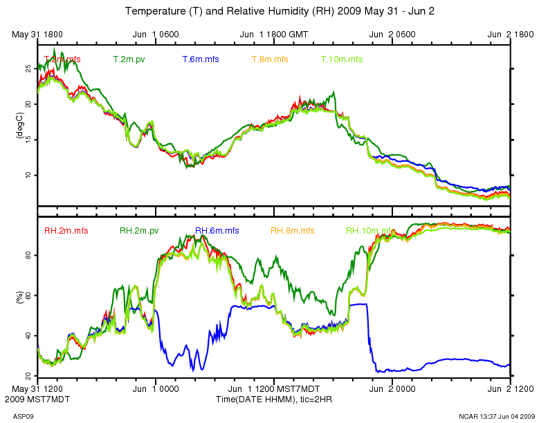
4m TRH at Marshall started generating intermittent data starting around 00:00 LT, May 30, and appears to have quit altogether by 04:00
If you let it run long enough, data_stats shows a record length of 8191 bytes which indicates that the data system is not finding a terminator (newline) in the data:
marshall:/dev/ttyS11 2 410 1 2009 06 01 17:18:06.062 06 01 17:18:06.062 nan 0.000 0.000 8191 8191
data_dump shows that the data is all NULLs (0x00):
cd /data/projects/ASP09/raw_data:
data_dump -i 2,410 -A isff_20090601_160000.dat
The serial driver is reporting a bazillion "break" events for that port:
ssh root@marshall
more /proc/tty/driver/serial
...
11: uart:ST16654 port:F1000170 irq:104 tx:13 rx:129438833 fe:32 brk:109632291 RTS|DTR
I recommend temporarily connecting a working TRH to port 11 and see if things look good.
At May 30 09:32 UTC (03:32 MDT) this TRH died until 03:49 MDT, then
looks like it reset itself, and worked until 03:56 MDT, and then died
completely. It did this same thing several times between 00:00
and 03:32 MDT.
2009 05 30 09:32:20.9023 0.8324 31 TRH013 16.73 37.69 5626 1173\r\n
2009 05 30 09:32:21.7418 0.8395 31 TRH013 16.72 37.73 5625 1174\r\n
2009 05 30 09:32:22.5737 0.8319 33 TRH013 16.71 37.73 5624 11\x07\x00\x00\x00\x00\n
2009 05 30 09:49:48.7838 1046 17 \r Sensor TRH013\n
2009 05 30 09:49:48.8031 0.01928 29 \rcalibration coefficients:\r\n
2009 05 30 09:49:48.8528 0.04968 21 Ta0 = -4.021784E+1\r\n
2009 05 30 09:49:48.8914 0.03862 21 Ta1 = 1.025356E-2\r\n
2009 05 30 09:49:48.9344 0.04306 21 Ta2 = -2.321813E-8\r\n
2009 05 30 09:49:48.9712 0.03673 21 Ha0 = -9.861796E+0\r\n
2009 05 30 09:49:49.0133 0.0421 21 Ha1 = 4.218116E-2\r\n
2009 05 30 09:49:49.0527 0.03948 21 Ha2 = -3.237849E-6\r\n
2009 05 30 09:49:49.0916 0.03889 21 Ha3 = 8.039271E-2\r\n
2009 05 30 09:49:49.1396 0.04793 21 Ha4 = 6.041142E-5\r\n
2009 05 30 09:49:49.4596 0.3201 31 TRH013 16.26 39.07 5579 1214\r\n
2009 05 30 09:49:50.2896 0.83 31 TRH013 16.25 39.14 5578 1216\r\n
29May09
Kurt measured the booms with the data-scope today.
These are magnetic readings with deviation setup as ......
GM: added true-north angles using declination shown below and assuming data-scope was not correcting for declinaton.
Site |
Ht |
BoomAngle |
BoomAngle(true) |
Vazimuth (Boom-90) |
|---|---|---|---|---|
Platteville |
4m |
88.9 (KK) 91.5 (Rudy) |
90.2 + 9 = 99.2 |
9.2 |
Marshall |
2m |
16.4 |
16.4 + 9 = 25.4 |
295.4 |
|
4m |
16.0 |
25 |
295 |
|
6m |
15.7 |
24.7 |
294.7 |
|
8m |
16.2 |
25.2 |
295.2 |
|
10m |
18.0 |
27 |
297 |
According to http://www.ngdc.noaa.gov/geomagmodels/struts/calcDeclination
the declination of Marshall (Lat: 39.948, Lon: 105.195) is 9 deg 17 min.
Platteville (Lat: 40.187, 104.72) is 9 deg 3 min.
29May09 ~14:00-14:50MDT Visit by KK/Rudy
-Q7 / Rnet installed. Verified data looked reasonable
- Local Storage Media swapped to check back at FL
- CSAT Boom Angle: KK says 88.9, Rudy says 91.5
29May09
The Rlw.in has been too warm for the last couple of days, producing erroneous looking data for rnet versus rsum.
Kurt cleaned the domes but did not see anything obviously unusual about the sensors or installation.
Keep-an-eye-on-it.
29May09 ~12:00 MDT
10m TRH's RH has been bad since it was installed yesterday. S/N16. Note SteveS mentioned he didn't get the raw data for the rh on this sensor, so it needs to be calculated and reprogrammed. For now we're doing the following:
2m TRH moved to 10m. S/N14
10m TRH s/n16 removed and swapped with TRH s/n10
Current Positions of sensors as of 29May09-pm
Level |
TRH S/N |
Notes |
|---|---|---|
2 |
10 (was 14) |
Keep an eye on it. |
4 |
13 |
|
6 |
15 |
Keep an eye on it. |
8 |
5 |
|
10 |
14 (was 16) |
|
9/29/09 15:00 MDT (TWH) RH profiles, including RH at 2m and 10m, look fine at the moment. It's a good time to check the profiles because they are close to constant with height due to good afternoon mixing. Swap seems to have worked great.
There is now a shared ISS operator account through which students and operators can log into the wiki and make log entries. See Gary for the credentials.
Sonic serial numbers. The marshall sonics were verified by checking /var/log/isfs/marshall_ASP09_csat3.log on the marshall adam.
|
|
|
|
site |
port |
height |
serial # |
|---|---|---|---|
marshall |
ttyS1 |
2m |
1120 |
marshall |
ttyS10 |
4m |
0673 |
marshall |
ttyS12 |
6m |
0536 |
marshall |
ttyS14 |
8m |
1124 |
marshall |
ttyS16 |
10m |
0672 |
platteville |
ttyS10 |
4m |
0537 |
Licor 7500 serial numbers, as noted by Kurt:
site |
port |
height |
serial # |
|---|---|---|---|
marshall |
ttyS8 |
2m |
1166 |
marshall |
ttyS19 |
10m |
0813 |
platteville |
ttyS11 |
4m |
1164 |
Prop vane at Platteville: SN: 0245. Boom angle: 355.2 magnetic
Radiometers:
Sensor |
Mars |
Platteville |
|---|---|---|
Rsw.in |
KZ-970378 |
KZ-940181 |
Rsw.out |
KZ-940187 |
KZ-940186 |
Rlw.in |
KZ-30676 |
EP-31977 |
Rlw.out |
KZ-970377 |
EP-31980 |
Rnet |
Q99258 |
Q99259 |
Note1: The KZ noted on the first line is what i saw on the cable and plenum. The 40740 is on a list Chris provided......need to double check this and vfy coefs in logger to be safe. The other sensors agree with his list.
Note2: Rnet Q94197 was installed initially at Platteville, but was swapped for 99259 on 6/4 since the logger had coefficients for that sensor instead.
Soil Sensors:
Sensor |
Mars |
Platteville |
|---|---|---|
Tsoil |
STP97003 |
STP98032 |
HFT |
H993562 |
H023009 |
TP01 |
200240 |
200236 |
Qsoil |
No Label |
No Label |
|
|
|
Note3: Chris' list agrees with what I show for Mars above.
The "aster" laptop in the ISFS trailer is accessible from inside the UCAR firewall at 128.117.81.3
ssh aster@128.117.81.3
From there one can ssh to the adam:
ssh root@marshall
The adam is on the 802.11 (wifi) subnet at 192.168.12.115.