12/28-30/2012 @ KCLE
December 28, 2012
WX Scenario:
Cloud shield affecting KCLE associated with two weak lows developing over the Lower Mississippi Valley. No surface precip reported at KCLE on this day.
Discussion:
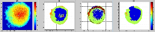
There is an area of SLW='yes icing' in the same northeasterly quadrant as the MOG PIREP in the radar volume for the polarized IHL. The non-polarized IHL has no SLW, but does have some spotty freezing drizzle at cloud tops that the polarized algorithm does not. ** I believe we are missing Ka-band data, thus missing NIRSS for this case **
PIREP: '20121228 0408 UTC 41.49 -81.76 CRJ2 BKL UA /OV CLE045006 /TM 0408 /FL030 /TP CRJ2 /SK OVC024 /TA UNKN /IC MOD RIME /RM DURD'
IHL 0.5 and 3.0 degree plots |
|
|---|---|

|

|
NEXRAD Images |
||
|---|---|---|
|

|

|
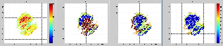
PING Images |
|---|

|
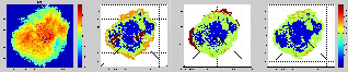
Discussion:
Mostly freezing drizzle detected in polarized IHL. Most of the S-band return pattern is west of the radar, so if the two departure null PIREPs on this day were easterly departures they would not have even encountered S-band return.
PIREP: '20121228 1428 UTC 41.42 -81.85 E145 CLE UA /OV CLE /TM 1428 /FLUNKN /TP E145 /SK TOP028/ SKC /TA UNKN /TB NEG /IC NEG /RM DURC'
IHL 3.0 and 0.5 degree plots |
|
|---|---|
|
|
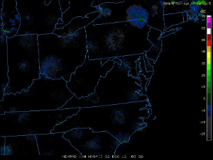
NEXRAD Images


NEXRAD Images |
|||
|---|---|---|---|
|
|
|
|
|
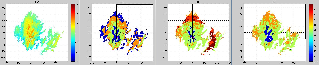
PING Images |
|---|

|
Discussion:
Most of the S-band return pattern is west of the radar, so if the two departure null PIREPs on this day were easterly departures they would not have even encountered S-band return.
PIREP: '20121228 1610 UTC 41.42 -81.85 CRJ7 CLE UA /OV CLE /TM 1610 /FLUNKN /TP CRJ7 /SK OVC015-TOP025 /TA UNKN /IC NEG /RM DURC'
IHL 3.0 and 0.5 degree plots |
|
|---|---|

|

|
NEXRAD Images


NEXRAD Images |
||
|---|---|---|
|
|
|
|
PING Images |
|---|
|
Discussion:
As the 'DRYER' hold pattern (call sign 'DJB') is west-southwest of KCLE, it makes sense that this pilot would call in a 'null' severity icing PIREP as it is evident from the IHL plots that the detected IFI at this time is all north of KCLE. Significant areas of SLW='yes icing' are detected north of KCLE at this PIREP time. The modified SLW algorithm for the non-polarized IHL does a fairly decent job of calling out SLW in the volume, but as is usually the case, the height of SLW is higher than the polarized IHL.
PIREP: '20121228 1720 UTC 41.36 -82.16 PA46 LPR UA /OV DJB /TM 1720 /FL080 /TP PA46 /TA M07 /IC NEG'
IHL 3.0 and 0.5 degree plots


NEXRAD Images


IHL 3.0 and 0.5 degree plots |
|
|---|---|
|
|
|
NEXRAD Images |
||
|---|---|---|
|
|
|
|
PING Images |
|---|

|
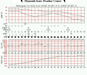
Meteogram |
|---|
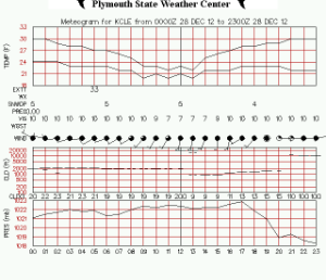
|
December 29, 2012
WX Scenario:
Strengthening 'Nor'easter' surface low over the mid-Atlantic causes northeasterly flow across Lake Erie and the development of a secondary low over southern Ohio. These synoptic dynamics destabilize the lower layers of the atmosphere in northern Ohio and over KCLE. Light snow at the surface begins at 09 UTC and continues through the end of the day.
Discussion:
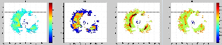
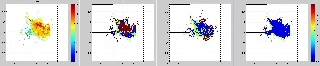
During the 11UTC hour, many icing PIREPs are reported. The PIREPS generally transition from 'light' severity to 'moderate' as the hour progresses. The polarized IHL sees large swaths of SLW='yes icing'. The non-polarized IHL sees areas of SLW='yes icing' at higher tilts, but almost no areas of positive severity in SLW at the lower tilts. Currently unknown as to why the non-polarized algorithm behaves in this manner. It is also curious to note that IHL has nearly zero freezing drizzle pixels, even near cloud top. Most other IFI cases shown on this page have at least some area of freezing drizzle especially at cloud tops.
PIREP: '20121229 1102 UTC 41.18 -82.16 A320 LPR UA /OV CLE225020 /TM 1102 /FLUNKN /TP A320 /TA UNKN /TB LGT CHOP 070-050 /IC LGT RIME 070-050 /RM DURD'
IHL 3.0 and 0.5 degree plots |
|
|---|---|

|

|
PIREP: '20121229 1132 UTC 41.44 -82.16 E145 LPR UA /OV DJB360005/TM 1132/FL090/TP E145/TA M11/IC LGT RIME/RM ALT 090 CLIMBING 120'
IHL 3.0 and 0.5 degree plots |
|
|---|---|

|

|
PIREP: '20121229 1151 UTC 41.42 -81.69 B737 BKL UA /OV CLE090007 /TM 1151 /FL100 /TP B737 /SK OVC015 /TA M13 /IC MOD RIME 090-135'
PIREP: '20121229 1154 UTC 41.42 -81.85 B737 CLE UA /OV CLE/TM 1154/FL090/TP B737/TA M13/IC MOD RIME/RM 135 ON TOP'
IHL 3.0 and 0.5 degree plots |
|
|---|---|
|

|
NEXRAD Images


NEXRAD Images |
|||
|---|---|---|---|
|
|
|
|
|
PING Images |
|---|

|
Discussion:
Large swaths of SLW='yes icing' persist with the polarized IHL in the radar domain and match with the reported PIREPs. The non-polarized IHL sees areas of SLW='yes icing' at higher tilts, but almost no areas of positive severity in SLW at the lower tilts. Currently unknown as to why the non-polarized algorithm behaves in this manner. ** Need to debug the Freezing Drizzle issue in the non-polarized IHL which occur outside the detectable S-band signal domain. **
PIREP: '20121229 1225 UTC 41.12 -81.46 CRJ2 AKR UA /OV CLE135025 /TM 1225 /FL120 /TP CRJ2 /TA M14 /IC MOD RIME 100-120'
IHL 3.0 and 0.5 degree plots |
|
|---|---|

|

|
PIREP: '20121229 1300 UTC 41.42 -81.41 A320 CGF UA /OV CLE090020 /TM 1300 /FL100 /TP A320 /TA 00 /WV 10010KT /IC LGT RIME'
IHL 3.0 degree plot |
|---|

|
NEXRAD Images


NEXRAD Images |
||
|---|---|---|
|
|
|
|
PING Images |
|---|

|
Discussion:
Large swaths of SLW='yes icing' persist with the polarized IHL in the radar domain and match with the reported PIREPs.
PIREP: '20121229 1426 UTC 41.42 -81.85 B737 CLE UA /OV CLE /TM 1426 /FLUNKN /TP B737 /SK OVCUNKN-TOP110 /TA UNKN /TB LGT CHOP 070-095 /IC LGT RIME 070-095 /RM DURC'
IHL 3.0 degree plot |
|---|

|
NEXRAD Images


NEXRAD Images |
||
|---|---|---|
|
|
|
|
PING Images |
|---|
|
Discussion:
The PIREP icing severities between 16 and 18Z all seem consistently 'light'. This seems to match a relative minima in percentage of radar volume denoted as SLW='yes icing' in the polarized IHL product. Conversly, the area of freezing drizzle ='yes icing' has expanded compared to previous and future times. There are significant areas of SLW='yes icing' in the modified SLW algorithm for the non-polarized IHL algorithm.
PIREP: '20121229 1611 UTC 41.30 -82.01 E145 LPR UA /OV CLE225010 /TM 1611 /FL040 /TP E145 /TA M06 /IC LGT RIME'
IHL 3.0 and 0.5 degree plots |
|
|---|---|

|

|
PIREP: '20121229 1637 UTC 41.42 -82.07 E145 LPR UA /OV CLE270010 /TM 1637 /FL030 /TP E145 /SK OVC030-TOP065 /TA M04 /IC LGT RIME 030-065 /RM DURC LYR ABV'
IHL 3.0 and 0.5 degree plots |
|
|---|---|

|

|
NEXRAD Images


NEXRAD Images |
|||
|---|---|---|---|
|
|
|
|
|
PING Images |
|---|

|
Discussion:
The PIREP icing severities between 16 and 18Z all seem consistently 'light'. This seems to match a relative minima in percentage of radar volume denoted as SLW='yes icing' in the polarized IHL product. Conversly, the area of freezing drizzle ='yes icing' has expanded compared to previous and future times. There are significant areas of SLW='yes icing' in the modified SLW algorithm for the non-polarized IHL algorithm.
PIREP: '20121229 1707 UTC 41.49 -81.76 DH8A BKL UA /OV CLE045006 /TM 1707 /FLUNKN /TP DH8A /SK OVC007-TOP060 /TA M04 /IC LGT RIME /RM IC'
IHL 3.0 and 0.5 degree plots |
|
|---|---|

|
|
PIREP: '20121229 1803 UTC 41.50 -81.85 E145 CLE UA /OV CLE360005 /TM 1803 /FL068 /TP E145 /SK BKN020-TOP068 /TA 00 /IC LGT RIME 020-068'
IHL 3.0 and 0.5 degree plots |
|
|---|---|

|

|
NEXRAD Images


NEXRAD Images |
||
|---|---|---|
|
|
|
|
PING Images |
|---|

|
Discussion:
PIREP: '20121229 1906 UTC 41.52 -81.61 E145 BKL UA /OV CXR270020/TM 1906/FL035/TP E145/IC LGT RIME/RM DURGC 035-080'
IHL 3.0 and 0.5 degree plots


NEXRAD Images


IHL 3.0 and 0.5 degree plots |
|
|---|---|
|
|
|
NEXRAD Images |
|
|---|---|
|
|
|
PING Images
PING Images |
|---|
|
|
Discussion:
PIREP: '20121229 2152 UTC 41.22 -81.85 B737 CLE UA /OV CLE180012 /TM 2152 /FL030 /TP B737 /SK OVC-TOP088 /TA M10 /TB LGT CHOP /IC LGT RIME 040-030 /RM DURD /TA M02 060'
IHL 3.0 and 0.5 degree plots |
|
|---|---|
|
|
NEXRAD Images


NEXRAD Images |
|||
|---|---|---|---|
|
|
|
|
|
PING Images

PING Images |
|---|
|
|
Meteogram

Meteogram |
|---|
|
|
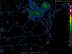
December 30 2012
WX Scenario:
As the Nor'easter pushes off the Atlantic coast, a Lake Effect snow event for KCLE sets up and persists throughout this day.
Discussion:
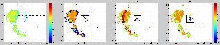
Lake Effect snow bands in the KCLE domain are seen to be oriented with the mean flow from northwest to southeast. The polarized IHL places a significant volume of SLW='yes icing' along the highest reflectivity areas of LE at all tilt angles. The non-polarized SLW algorithm completely misses the embedded mixed phase icing. In fact the SLW area is nearly the perfect inverse of the high reflecitivity snowband areas. As with the onset of icing on the previous day, nearly zero freezing drizzle volume is detected at this time ( an interesting trend to keep an eye on!). The LE band existance is well represented in the PING plot.
PIREP: '20121230 1530 UTC 41.42 -81.96 B737 CLE UA /OV CLE270005 /TM 1530 /FL073 /TP B737 /SK BKNUNKN-TOP073 /TA M14 /IC LGT RIME 030 BLO /RM DURD'
IHL 3.0 and 0.5 degree plots |
|
|---|---|

|

|
NEXRAD Images


NEXRAD Images |
||
|---|---|---|
|
|
|
|
PING Images |
|---|

|
Discussion:
There indeed is no icing in the northwest quadrant at the time of this null icing severity PIREP as the LE band has shifted east of KCLE. The bands eastward translation is clearly evident in the NEXRAD reflectivity images. IHL nonetheless detects significant SLW='yes icing' in the band. The same inverse relation with the non-polarized SLW algorithm exists at this time.
PIREP: '20121230 1710 UTC 41.48 -81.93 E135 CLE UA /OV CLE315005 /TM 1710 /FLUNKN /TP E135 /SK OVC021-TOP040 /TA UNKN /IC NEG /RM SKC ABV 040'
IHL 0.5 and 3.0 degree plots |
|
|---|---|

|
|
NEXRAD Images


NEXRAD Images |
||
|---|---|---|
|
|
|
|
PING Images

PING Images |
|---|
|
|
Discussion:
The bands eastward translation is clearly evident in the NEXRAD reflectivity images. IHL nonetheless detects significant SLW='yes icing' in the band. The same inverse relation with the non-polarized SLW algorithm exists at this time.
PIREP: '20121230 1908 UTC 41.42 -81.98 DH8A CLE UA /OV CLE270006 /TM 1908 /FL030 /TP DH8A /SK OVC012-TOP030 /TA M08 /IC LGT RIME 012-030 /RM DURC'
IHL 3.0 and 0.5 degree plots |
|
|---|---|

|

|
NEXRAD Images


NEXRAD Images |
||
|---|---|---|
|
|
|
|
PING Images

Meteogram
PING Images |
|---|
|
|
Meteogram |
|---|
|
|