Manitou Forest Observatory
Introduction
This document provides an overview of the NCAR Manitou Forest Observatory, a forested research site recently developed through funding from the Bio-hydro-atmosphere interactions of Energy, Aerosols, Carbon, H2O, Organics & Nitrogen (BEACHON) program at the NationalCenter for Atmospheric Research (NCAR). The site is located in a montane ponderosa pine zone in the Central Rockies near Woodland Park,Colorado(7500' elev., lat. 39°6'0" N, long. 105°5'30" W), which is part of a larger zone that extends from Northern New Mexico to Southern Wyoming and is a component of the dominant Western U.S. ponderosa pine forest type that extends from Mexico to Canada. The site is representative of the semi-arid Western U.S. where biosphere-atmosphere exchange processes of energy, water, carbon, and nitrogen are particularly sensitive to changes in precipitation. While the site is located close to a major urban corridor (the Front Range Urban Corridor, which stretches from Pueblo, Colorado, north along Interstate Highway 25 to Cheyenne, Wyoming), measurements of trace gases and ambient aerosol at the site suggest that it is largely shielded from anthropogenic air masses due to its unique location in a north-south aligned valley separated from the Front Range Urban Corridor by the Rampart Range to the east, and Pike's Peak to the south; exceptions include episodic intrusions of anthropogenic air in evening downsloping air from the north. The site is located in a relatively flat valley with a reasonable upwind fetch, a topography that is amenable to performing flux measurements using micrometeorological techniques. The canopy is open and of varying density, with mixed-age ponderosa pine up to 100 years old and a surface cover of grasses, sage, crocus, forbs and exposed cryptogrammic soils.
Accommodation for about 30 visitors is available about 1 km from the site, with additional lodging available in the town of Woodland Park located 8 miles away. Currently the site features a 30m canopy tower (twice the forest canopy height), a 45m flux tower, 200A of 3-phase power, broadband internet, and 4 movable 8'x20' research laboratories.
Location
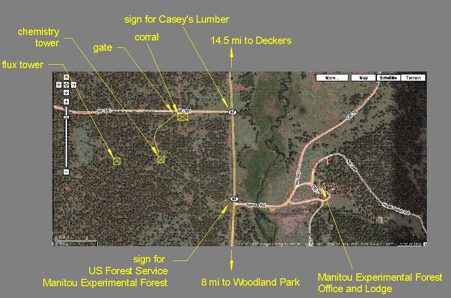
The site is located west of Highway 67, 8 miles north of Woodland Park, Colorado. The approximate altitude of the site is 7500' elev., and it's GPS coordinates are lat. 39°6'0" N, long. 105°5'30" W. MFO is located within the boundaries of the US Forest Service's Manitou Experimental Forest (MEF, http://www.fs.fed.us/rmrs/experimental-forests/manitou-experimental-forest/), and benefits from a close collaboration between NCAR and MEF staff. The site is allocated for seasonal grazing activity for approximately 37 days from 27 July to 1 September, however, a lack of open water in the allocation has discouraged the permittee from actually exercising his right to graze his cattle there for the past several years.
Detailed satellite image of the site:
Driving Directions
MFO is easily accessed by researchers who reside in the Front Range Urban Corridor (e.g., two hours driving time from Boulder,CO).