4June09
CG measured the top of the booms for:
Nominal |
Meas. |
Meas. |
|---|---|---|
2m |
1.98 |
2.3 |
4m |
4.02 |
4.07 |
6m |
5.89 |
6.32 |
8m |
8.0 |
8.45 |
10m |
10.2 |
10.61 |
4June09 ~10:15-11:15MDT Site Visit Platteville
Echo Probe swapped (these have no serial numbers): Previous unit was reporting negative values per TH. From raw file data from 'yesterday' was
182,1,12.27,0,15.173,0,-56.044,-4.6824,-2.2093,83191,8.9592,8.844,9.7848,9.6367,13.517,39.416,435.39,1.2594,0,0,-9999
where vqsoil,qsoil is '435.29,1.2594' Note the rsw values appear odd in that....
New unit per rserial is reporting messages like this:
182,1,13.24,0,464.1,0,-47.208,23.373,820.48,127.9,19.809,20.507,17.573,17.611,19.076,-61.372,423.8,.45439,0,0,-9999
182,1,13.24,0,513.61,0,-45.46,24.308,1005.7,152.81,19.809,20.603,17.573,17.632,19.055,-61.26,423.8,.45439,.00335,0,-9999
where the vqsoil/qsoil is the '423.8,.45439' versus '435.39,1.2594' above. Meanwhile Mars is reporting:
166,2,11.55,0,521.44,0,-88.63,29.675,820.27,127.64,1.0656,23.434,1.1063,22.442,23.388,-86.93,509.36,6.4007,.02996,0,-9999\r\n
166,2,11.56,0,539.42,0,-88.63,29.675,867.57,131.35,1.0656,23.434,1.1066,22.435,23.368,-86.806,508.69,6.3538,.02996,0,-9999\r\n
with vqsoil, qsoil '508.69,6.3538'
So it appears maybe all these qsoils are about the same so I'm not convinced it is fixed....checking logger coef.....
Calib. Coefs in loggers: Location 45,46,47 are for the Qsoil and are the same for both loggers....guess we'll just need to keep an eye on it...
Loc |
Mars |
Platteville |
|---|---|---|
00 |
9.3500 |
9.07 |
|
|
|
4June09 ~10:15-11:15MDT
Pocketec Swapped. Brought unit taken back for data merge.
Photos taken. Sensor serial numbers confirmed.
Q7 swapped: We had installed the 'wrong' Rnet for the coefficients in the logger. Out=Q94197 In=Q99259

NIMA is crashing on the ISS, so the plots of the improved spectra and winds will not be available until it is fixed. I'm trying to upgrade to the latest source and rebuild it to see if that fixes the problem.
As of yesterday, around 2009-06-03 18:00 UTC, the mobile ISS is up and running at Marshall. Real-time plots are available at this page:
http://www.eol.ucar.edu/isf/projects/asp/iss/realtime/summary/iss1/
The Internet link uses an etherant (ip 192.168.12.37) to the ISFS base trailer. The ISS workstation uses DHCP for its eth1 interface, and so far it has been assigned 192.168.12.250. Interface eth0 is the local trailer network, 192.168.1, on which the ISS profiler PC, sounding laptop, and ceilometer laptop are connected. The aster machine is at 192.168.13.1, which provides the routing gateway and DNS to the ISS workstation.
The network has been reliable so far, and data are flowing every half hour from the ISS site.
A web page for ISS for the ASP colloquium has been created here:
3June06 ~10:30MDT
Rlw.in had been bad. Found loose ground wire on the excitation line. Twiddled/secured wires. Now working
Rlw.in Rpile reading ~ -20w/m2 with voltage ~ .2mV
Rlw.out Rpile reading ~ 20w/m2 with voltage ~ .2mV
3June06 ~10:15MDT
4m TRH swapped because it'd been bad (See GM's note) sn-out=13 sn-in=008 It was generating continuous spurious interrupts. Only the michro-chip 'wand' was replaced, not the shield.
6m TRH removed s/n15 because of bad 'shield' (dc-dc, sio, etc). Swapped 2m TRH up to 6m to avoid climbing later: sn10 is now at 6m
|
Level |
TRH S/N |
Notes |
|---|---|---|---|
2 |
|
Will be replaced later today....... |
|
4 |
8 |
Installed today |
|
6 |
10 |
Swapped in from 2m today |
|
8 |
5 |
|
|
10 |
14 |
|
|
3June09 ~10:15MDT
The Li7500 that was at 2m was raised to 4m per request by SO/TH.
It has the same serial port in xml config., but the height qualifier was changed from 2m to 4m also.
NOTE: Retained the mounting arrangement so we moved the sonic from 2 to 4 along with it,
and thus the 4m sonic to 2m as well. Will change the serial number entry for this
Recall setting 'ZN' on boom worked ok.
Boom Angle setup: BD359 as I recall....need to confirm KK's reading when he shot it.
Confirmed readings consistent with observed conditions, and manually rotating vane while mast was lowered.
The 6m RH deviates from the others when the RH is above 50 %.
4m TRH still not reporting. 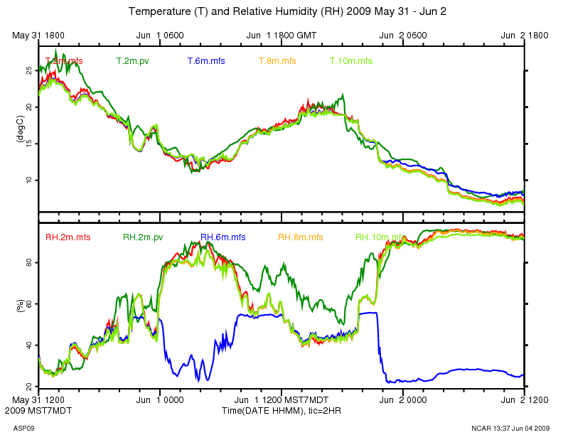
4m TRH at Marshall started generating intermittent data starting around 00:00 LT, May 30, and appears to have quit altogether by 04:00
If you let it run long enough, data_stats shows a record length of 8191 bytes which indicates that the data system is not finding a terminator (newline) in the data:
marshall:/dev/ttyS11 2 410 1 2009 06 01 17:18:06.062 06 01 17:18:06.062 nan 0.000 0.000 8191 8191
data_dump shows that the data is all NULLs (0x00):
cd /data/projects/ASP09/raw_data:
data_dump -i 2,410 -A isff_20090601_160000.dat
The serial driver is reporting a bazillion "break" events for that port:
ssh root@marshall
more /proc/tty/driver/serial
...
11: uart:ST16654 port:F1000170 irq:104 tx:13 rx:129438833 fe:32 brk:109632291 RTS|DTR
I recommend temporarily connecting a working TRH to port 11 and see if things look good.
At May 30 09:32 UTC (03:32 MDT) this TRH died until 03:49 MDT, then
looks like it reset itself, and worked until 03:56 MDT, and then died
completely. It did this same thing several times between 00:00
and 03:32 MDT.
2009 05 30 09:32:20.9023 0.8324 31 TRH013 16.73 37.69 5626 1173\r\n
2009 05 30 09:32:21.7418 0.8395 31 TRH013 16.72 37.73 5625 1174\r\n
2009 05 30 09:32:22.5737 0.8319 33 TRH013 16.71 37.73 5624 11\x07\x00\x00\x00\x00\n
2009 05 30 09:49:48.7838 1046 17 \r Sensor TRH013\n
2009 05 30 09:49:48.8031 0.01928 29 \rcalibration coefficients:\r\n
2009 05 30 09:49:48.8528 0.04968 21 Ta0 = -4.021784E+1\r\n
2009 05 30 09:49:48.8914 0.03862 21 Ta1 = 1.025356E-2\r\n
2009 05 30 09:49:48.9344 0.04306 21 Ta2 = -2.321813E-8\r\n
2009 05 30 09:49:48.9712 0.03673 21 Ha0 = -9.861796E+0\r\n
2009 05 30 09:49:49.0133 0.0421 21 Ha1 = 4.218116E-2\r\n
2009 05 30 09:49:49.0527 0.03948 21 Ha2 = -3.237849E-6\r\n
2009 05 30 09:49:49.0916 0.03889 21 Ha3 = 8.039271E-2\r\n
2009 05 30 09:49:49.1396 0.04793 21 Ha4 = 6.041142E-5\r\n
2009 05 30 09:49:49.4596 0.3201 31 TRH013 16.26 39.07 5579 1214\r\n
2009 05 30 09:49:50.2896 0.83 31 TRH013 16.25 39.14 5578 1216\r\n
29May09
Kurt measured the booms with the data-scope today.
These are magnetic readings with deviation setup as ......
GM: added true-north angles using declination shown below and assuming data-scope was not correcting for declinaton.
Site |
Ht |
BoomAngle |
BoomAngle(true) |
Vazimuth (Boom-90) |
|---|---|---|---|---|
Platteville |
4m |
88.9 (KK) 91.5 (Rudy) |
90.2 + 9 = 99.2 |
9.2 |
Marshall |
2m |
16.4 |
16.4 + 9 = 25.4 |
295.4 |
|
4m |
16.0 |
25 |
295 |
|
6m |
15.7 |
24.7 |
294.7 |
|
8m |
16.2 |
25.2 |
295.2 |
|
10m |
18.0 |
27 |
297 |
According to http://www.ngdc.noaa.gov/geomagmodels/struts/calcDeclination
the declination of Marshall (Lat: 39.948, Lon: 105.195) is 9 deg 17 min.
Platteville (Lat: 40.187, 104.72) is 9 deg 3 min.
29May09 ~14:00-14:50MDT Visit by KK/Rudy
-Q7 / Rnet installed. Verified data looked reasonable
- Local Storage Media swapped to check back at FL
- CSAT Boom Angle: KK says 88.9, Rudy says 91.5
29May09
The Rlw.in has been too warm for the last couple of days, producing erroneous looking data for rnet versus rsum.
Kurt cleaned the domes but did not see anything obviously unusual about the sensors or installation.
Keep-an-eye-on-it.
29May09 ~12:00 MDT
10m TRH's RH has been bad since it was installed yesterday. S/N16. Note SteveS mentioned he didn't get the raw data for the rh on this sensor, so it needs to be calculated and reprogrammed. For now we're doing the following:
2m TRH moved to 10m. S/N14
10m TRH s/n16 removed and swapped with TRH s/n10
Current Positions of sensors as of 29May09-pm
Level |
TRH S/N |
Notes |
|---|---|---|
2 |
10 (was 14) |
Keep an eye on it. |
4 |
13 |
|
6 |
15 |
Keep an eye on it. |
8 |
5 |
|
10 |
14 (was 16) |
|
9/29/09 15:00 MDT (TWH) RH profiles, including RH at 2m and 10m, look fine at the moment. It's a good time to check the profiles because they are close to constant with height due to good afternoon mixing. Swap seems to have worked great.