
Here is a list of what I know about sensors at each site:
Site |
Battery |
Sonic |
Krypton |
Baro |
TRH |
Rad |
Soil |
Soil.aux |
Precip |
Shadowband |
Prop |
|---|---|---|---|---|---|---|---|---|---|---|---|
1 |
ok |
head off |
not installed |
ok |
not installed |
Rsw.in a bit strange, but went |
ok |
ok |
not planned |
SPN1 reporting 0 |
ok |
2 |
ok |
ok |
not installed |
ok |
not installed |
Rsw.in<Rsw.out |
ok |
not planned |
not planned |
not planned |
not planned |
3 |
charging? |
ok |
<5mV |
ok |
not installed |
ok |
turned off? |
not planned |
no fluid |
not planned |
not planned |
4 |
ok |
ok |
not installed |
ok |
not installed |
ok |
Qsoil bit high |
not planned |
reporting all 0 |
not planned |
not planned |
5 |
ok |
ok |
<5mV |
ok |
problem -1<T<0 |
Rsw.in high by x2 until 11/14 |
Qsoil started being |
Tsoil.4.4cm bad |
not planned |
not planned |
not planned |
6 |
ok |
ok |
<5mV |
ok |
not installed |
turned off? |
turned off? |
turned off? |
no fluid |
not planned |
ok |
7 |
ok |
ok |
<5mV |
ok |
problem -1<T<0 |
ok |
ok |
not planned |
not planned |
ok |
not planned |
Well...we already know about I2C problems with the TP01 on site5.aux. I note now that Qsoil is erratic at this site and even Gsoil had a spike yesterday that wasn't seen at any other site. Tsoils are consistently okay, though. At the very least, it might be a good idea to reseat these connections in the mote box.
P.S. As of ~1700 on 13 Nov, we're losing Tsoil.4cm as well. I wonder if gophers are getting to these sensors??? I sure hope not.
I also note that all Qsoils show a small spike when the TP01 is heating. The amplitude is small enough to be ignored (about 3 A/D counts), but we should be aware of this.
We have found a bug in the humitter code where the output format is incorrect for temperatures between 0 and -1 C. This causes both T and RH values to be reported as missing. Examples are:
2010 11 12 12:28:44.0730 0.9708 29 TRH20 0.00 66.96 4004 2164\r\n
2010 11 12 12:28:45.0522 0.9793 30 TRH20- 0.02 66.95 4001 2164\r\n
2010 11 12 13:53:16.4885 0.97 30 TRH20- 0.99 74.28 3906 2430\r\n
2010 11 12 13:53:17.4685 0.98 30 TRH20 -1.01 74.27 3904 2430\r\n
The humitters thus will have to be reprogrammed. Current thinking is to send all of them back to Boulder for Steve to fix.
This also is an issue for one (TRH11@7m) of the Manitou sensors.
I note that since we are for the first time mounting the barometer outside of the DSM box, Tbaro changes much faster than before. In particular, in the past 30minutes this morning, Tbaro has changed at the east sites from being nearly equal to T to being almost 10degrees higher. I assume this is due to heating by shortwave radiation as the station comes out of the shadow of the mountains.
The barometer pressure is compensated for changes in its temperature and is still well within its calibrated range, but it is possible that this rate of change could induce temperature gradients within the sensor that makes the Tbaro measurement (and thus any compensation) less valid. It would be interesting to examine these pressure data in detail during these times to see if an error in pressure can be detected. (Though it isn't obvious what the reference would be.)
Dynamic DNS
Immediately after the cellular modem connects to the Verizon ISP, the station registers itself with the dynamic name service, dyndns.com.
So, a good remote check on whether the cellular modem and router are working is to login to our account at http://dyndns.com and check the times of the host registrations.
Ask Gordon, Ling or Gary for our account name and password at dyndns.com.
Once you're logged in, click on the My Hosts link. You will see the 7 isfs stations, and two spares, along with the iss systems. The time (MST) that a station last registered with dyndns is shown. Click on Host Update Logs to see a listing of all recent registrations.
ping
Each of the stations should also be reachable via ping:
ping isfs1.dyndns.org
At site about 1400-1500. Lots of standing water. Need a hard hat and should check in at office trailer.
Tower site placed near E fence in NE corner on gravel. A bit of a notch between buildings for N winds and relatively open to S. Told not to worry about E winds, so plan on tower dropping to W. Rad stand placed out more in the gravel to give better exposure. Would be nice to set this stand as low as possible to minimize vegetation in field of view.
Soil was wet, sticky, black, relatively large granuals with a few stones (and worms!). Actually not too bad to work in. Placed near solar panel location. Again, couldn't test sensors. 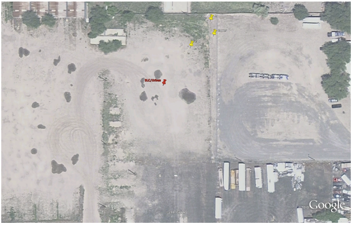
At site, perhaps 1145-1300. Rain less, but turned to cold fog.
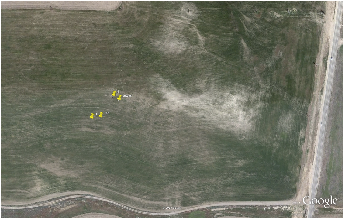
Chose to move from last night's location since Tom and I couldn't figure out how to interpret data over a combo of sagebrush and tilled field. Dave contacted landowner and told anywhere in the stubble field was okay.
New tower site chosen in middle of wheat stubble field to minimize effect of 3m deep x 30m wide gulley to south and high mound to north. Rad stand still to SSW of tower. Despite discussions at the previous site6 location concerning the sonic height, IT WILL BE 3m AS ORIGINALLY PLANNED AT THIS SITE.
Soil black, sticky, globular (like site 4). Again, couldn't (re)test these sensors.
At site about 1045-1130. Still raining -- used canopy.
Tower site picked to avoid building for NNW winds. Rad stand put on east side in case of west winds. Should be able to drive quite close on track from parking lot.
Soil installed. Sticky, globular black clay. Quite wet. Lots of dog droppings in this area (including the soil site). Did not check sensor function.
At site ~0830-1000 with Jeff Lachowski from Kennecott. Driving rain from the west. White spots in Google had standing water.
Combo locks on two gates. (silver lock on first gate). Should inform Jeff when entering/exiting site. Hardhats and googles should be worn.
Decided on site on the southern boundary to minimize effect of berm to the north. South and West winds should be great.
Soils installed, 1 near rad stand (to west to minimize cross section to radiometers), 2 NW of tower. Soil was dry on bottom, clayey in layers, but not obviously saline. Gel-cell battery was down to 6.7V -- was able to see sensor IDs, but no data.

[THIS IS OLD -- SITE RELOCATED]
At site from about 1645-1745 (left in dark).
Dave says that he drove to site location (perhaps following the path drawn) in a 4WD vehicle. Walking through the sagebrush was obnoxious. Set-up crew should have Dave shown them the correct path.
Took a while to decide on site Dave had selected. In the end, decided that an acceptable sonic height could be found, though perhaps not the 3m that was originally thought. The issue is that the local sagebrush is significantly rougher than surrounding fields, but not extensive enough to dominate a flux footprint.
Sited rad stand to W by ~50m This could be upwind for local downslope winds, but affect judged to be minor (compared to affect on radiometer view of large rocks and/or sagebrush elsewhere). Two soil sites were installed, again one near rad stand and one near tower. Soil appeared to be dark, fluffy, loam in both cases with just a few rocks. TP01 "cap" lifted out like lasagne. Sensors tested okay (Gsoil positive).
[removed image, since site relocated next day]
Visited site from about 1545-1630.
Chose tower site at top of (very minor) hill. Although soil at the tower was quite dry, chose more representative lower ground for rad stand and soil. Rad has view of minor trees (we avoided being next to slightly larger ones). Soil solar panel might be in field of view of rads, but judged negligible.
Soil was clayey, but slightly drier on top than site 3. Also rocky. Still moist below. Didn't try to make "cap" over TP01 since layer crumbled. Sensors tested good (Gsoil just slightly positive). 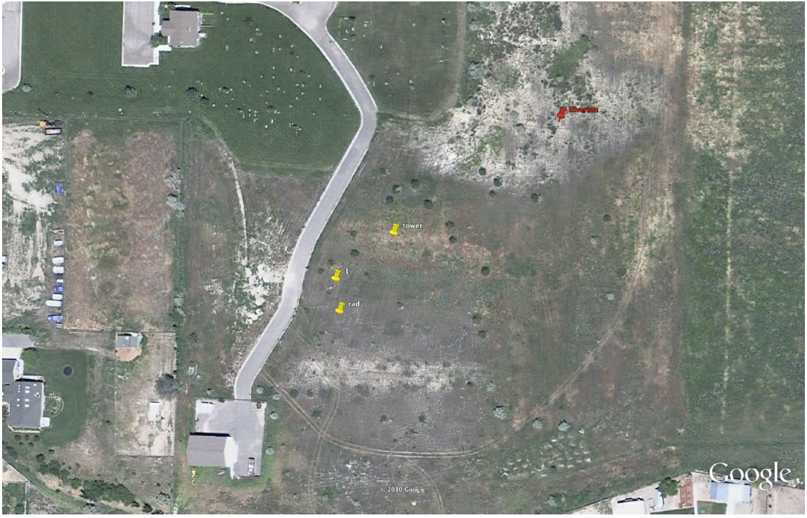
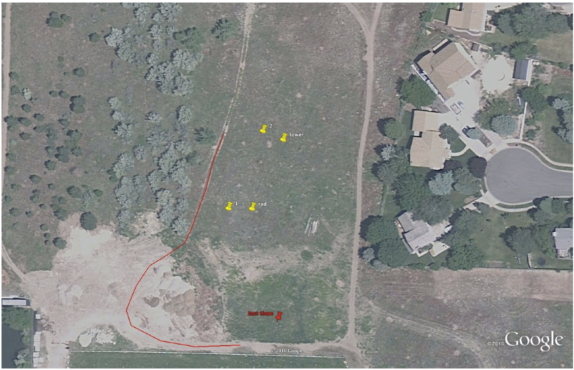
I think from ~1400-1500 flagged and installed soils at East Slope.
Chose tower location on ridge top with reasonably good exposure north and south. East exposure (from Big Cottonwood canyon drainage) is directly over houses, though tried to avoid being downwind of the <biggest> trees. Also tried to center between 2 footpaths, both of which were used by locals while we were there. Chatted with local homeowner who said he'd keep an eye on the site.
Soil very crumbly with gopher holes. Hopefully we won't have chew problems with our soil sensors! All sensors in first replicate (near rad stand) tested okay. TP01 in second replicate (near tower) didn't show up (via I2C) after several power cycles and white button pushes. Other sensors were fine (Gsoil still negative).
In below image (from memory), locations of the tower, rad stand, and soil sites 1 and 2 are marked. Also drawn is the access route we used.
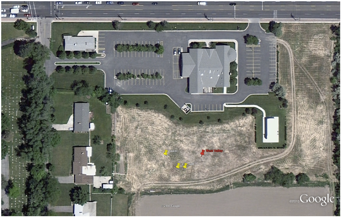
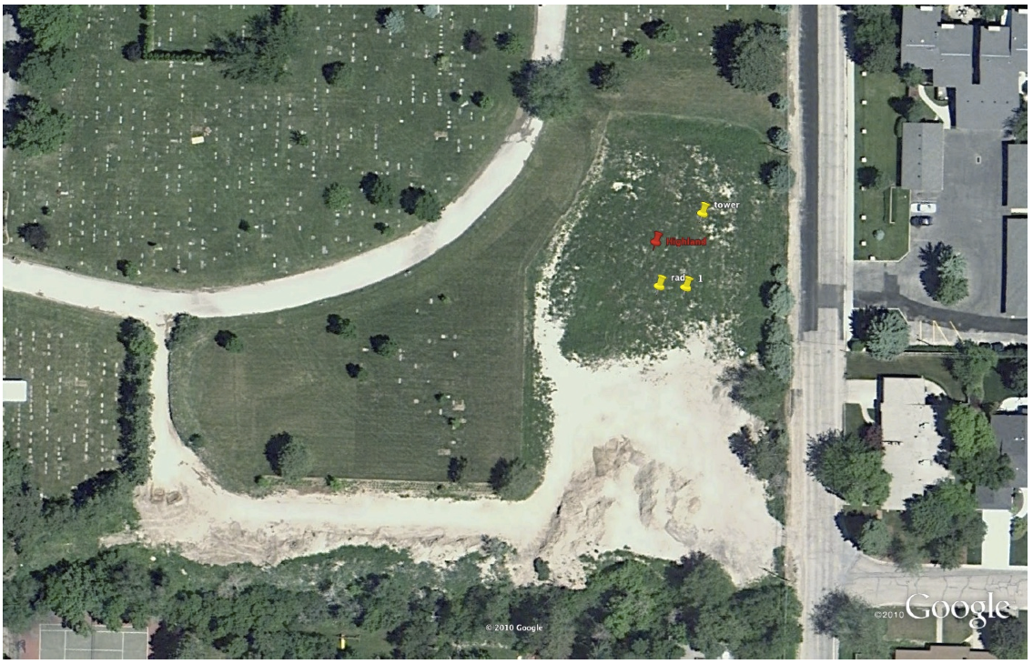
From about 1:00-1:45 flagged tower and rad locations and installed soil sensors.
Soil rather clayey and held together reasonably well. Sensors tested okay with John's setup (Gsoil negative).
Small site, so rad stand is reasonably close to tower. Tower placed close to road site to avoid potential footpaths nearby. We noted that the townhomes to the east don't have windows that will look out on this site.
A start at a site visit task list (with what I remember from Kurt's lesson):
- lower the tower:
- grab charged drill battery
- set mast support
- attach winch (rotated at angle)
- attach pulley (just outside bolts)
- loosen winch, attach carabiner to mast cable, tighten winch
- release front guy
- remove plate
- lower with drill about 1/3 trigger on lowest power (1)
- watch front footpad while lowering
- ease onto mast support
- clean krypton
- inspect sonic/prop/etc.
- raise the tower:
- inspect welds at all tower junctions
- inspect integrity of bottom pivot block
- inspect battons for being perpendicular to mast
- inspect side guy turnbuckles
- ensure that front guy won't catch
- raise in one smooth motion, full trigger on power (1)
- slow trigger power near end
- second person pushes in
- secure plate
- secure front guy and cable tie
- loosen winch tension
- detach carabiner
- detach pulley
- remove winch
- listen for T/RH fan
- inspect pressure port
- take gravimetric soil sample using corer -- both 0-3 and 3-6cm layers. Process entire sample for bulk density.
- clean all radiometers with Kim-Wipes and distilled water (alcohol [or methanol?] if freezing??)
- adjust shadowband on radiometers (done by Utah?)
- connect to data system via wifi
- check sensors okay (run cockpit?)
- check USB disk status
- check 3G network connection
- check network time drift