...
I begin with a comparison of the SPN1 global radiation to Rsw.in from the K&Z CM21 at NEAR and FAR..
I need a latitude and longitude for editing the solar radiation data by sun angle.
Cannot currently access the GPS lat/lon, so use those measured by Oncley at the end of the project. This is not all that critical for FLR and NEAR.
For the FLR radiation stand, SPO measured
latitude = 35d 01.680' = 35.028
longitude = 111d 01.353' = -111.05588
Then
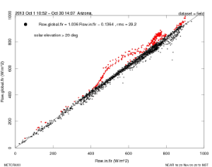
At NEAR, select data with sun elevation greater than 15 degrees (this limit is not critical). The median ratio of Rsw.global/Rsw.in = 0.9938. I note, however that there is hysteresis in the plot of Rsw.in.global versus Rsw.in. This is consistent with the observation that the up-facing radiometers at NEAR were not perfectly leveled because of problems with the radiometer mounting device.
| Section | ||||
|---|---|---|---|---|
|


| Section | ||||
|---|---|---|---|---|
|